El Hierro is the smallest and the remotest of the seven big Canary Islands. It is a peaceful place, far away and totally different from the busy tourist resorts of south Tenerife or Gran Canaria. El Hierro is especially suitable for those who are looking for a holiday in nature and it is an excellent walking destination.
Location
El Hierro is the island located furthest to the west and furthest to the south of all the Canary Islands. The closest islands are La Gomera 60 km to the east-northeast and La Palma 67 km to the north-northeast.
The coordinates of El Hierro are 27°45′ N 18°00′ W.
The island’s nickname is Isla del Meridiano (the Meridian Island) referring to the fact that El Hierro was the westernmost point of the known world for centuries and determined the prime meridian for maps used in various countries ranging from Ancient Egypt to Richelieu’s France.
On El Hierro you are more than one fourth on the way from Spain to Brazil. The distance between El Hierro and Isla Canela, the closest point in mainland Spain, is 1,442 km. The distance between El Hierro and Calcanhar Lighthouse in Brazil is approximately 4,092 km.
Surface and Landscape
As the smallest of the seven main Canary Islands, El Hierro has surface area of 278 km². The length of its shoreline is about 87 km.
Like all the other Canary Islands, El Hierro has volcanic origin. It is geologically the youngest and together with La Palma the most volcanically active of the seven big islands. Bubbling seawater caused by underwater eruptions could be observed in the recent years just off the shore of El Hierro, where an underwater volcano is apparently growing.
Pico de Malpaso
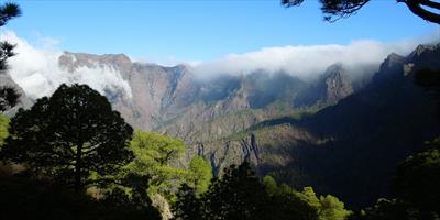
The highest mountain on El Hierro is Pico de Malpaso (Peak of Malpaso). It is 1,501 metres above sea level. Like other mountains in the Canary Islands and like the islands themselves, Pico de Malpaso has volcanic origin.
There are several pathways which you can take to the top of the Malpaso. Along the way you will see the changing nature of El Hierro vegetation and landscape. You will also see many pieces of evidence that Pico de Malpaso originated as a volcano. You will see lapilli fields and the typical Canary pine forests.
If you don’t want to walk too long, you can take a taxi from El Pinar to Cruz de los Reyes. From Cruz de los Reyes it is only a short walk to the peak of Malpaso with much fewer metres to climb. The downside is that you miss some beautiful scenery along the way.
Once you make it to the top (and if you are lucky enough to get good weather), you can see the whole island of El Hierro, as well as four other islands far behind the sea – La Palma, La Gomera, Tenerife (with the characteristic Mount Teide) and Gran Canaria.
Though the Canary Islands are known for their pleasant climate, the common stereotype of clear sky and pure sunshine is not always valid at Pico de Malpaso. The mountain is 1,501 metres above see level and you should be prepared for much lower temperature compared to the coast, as well as for wind, and even rain. The weather situation is constantly changing at the high altitude of Pico de Malpaso, so be prepared for all scenarios.
Population
Total population of El Hierro is 10,162 (as of 2003). From the administrative point of view, El Hierro belongs to the Tenerife province (the capital of this province is Santa Cruz de Tenerife).
There are only three municipalities on El Hierro: El Pinar, Frontera and not least Valverde, which is the capital and the biggest town with population of 5,797.