Introducing Fuerteventura
Fuerteventura is located 84 km to the east from Gran Canaria and 11 km to the south from Lanzarote. It is the closest one of the Canary Islands to Africa. At one point the distance to the Moroccan coast is only 95 km.
The coordinates of Fuerteventura are 28°20′ N 14°00′ W.
Size and Surface: the Flat Island
Fuerteventura has a surface area of 1,660 km² and is therefore the second largest of the Canary Islands (after Tenerife). It is about 100 km long (approximately north-south) and 31 km wide at its widest point.
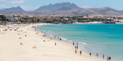
The landscape on Fuerteventura is quite different from that on the other islands. The first thing you will probably notice is that the mountains are not that high and not that broken. The highest point on Fuerteventura, Pico de la Zarza or also known as Pico de Jandia, is only 807 metres above sea level. Most of the “mountains” including Pico de Jandia are located on the small Jandia Peninsula in the south-western end of Fuerteventura (the part of the island closest to Gran Canaria).
Jandia Peninsula is connected with the rest of Fuerteventura by the 5 km wide Pared Isthmus (Istmo de la Pared), which is the narrowest point of the island. The larger northern part of Fuerteventura is rather flat.
This is because Fuerteventura (together with the neighbouring Lanzarote) is the oldest of the Canary Islands. It probably first appeared above the sea level more than 20 million years ago. The last volcanic activity on Fuerteventura occurred about 4,000 years ago.
Fuerteventura Beaches
To visitors this island is best known for its long beaches covered either with white sand or black volcanic shingle. Due to the island’s proximity to Africa and its surface the climate on Fuerteventura is very warm and very arid. Average annual precipitation is only 147 mm. On the other hand, sandstorms (known as calima) are common. They bring sand from the Sahara and can rapidly increase temperature for a while.
Fuerteventura Population and Towns
Population density on Fuerteventura is much lower than on the other Canary Islands. Total population is about 75,000.
From the administrative point of view, Fuerteventura is a part of the Las Palmas province (the capital of this province is Las Palmas on Gran Canaria).
There are six municipalities on Fuerteventura: Antigua, Betancuria, La Oliva, Pajara, Puerto del Rosario, and Tuineje. Puerto del Rosario is the largest city (population of 28,357) and the capital of the island.